

- 3.88 MB
- 13页
- 1、本文档共5页,可阅读全部内容。
- 2、本文档由网友投稿或网络整理,如有侵权请及时联系我们处理。
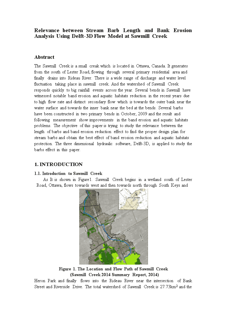
'RelevancebetweenStreamBarbLengthandBankErosionAnalysisUsingDelft-3DFlowModelatSawmillCreekAbstractTheSawmillCreekisasmallcreakwhichislocatedinOttawa,Canada.ItgeneratesfromthesouthofLesterRoad,flowingthroughseveralprimaryresidentialareaandfinallydrainsintoRideauRiver.Thereisawiderangeofdischargeandwaterlevelfluctuationtakingplaceinsawmillcreek.AndthewatershedofSawmillCreekrespondsquicklytobigrainfalleventsacrosstheyear.SeveralbendsinSawmillhavewitnessednotablebanderosionandaquatichabitatsreductionintherecentyearsduetohighflowrateanddistinctsecondaryflowwhichistowardstheouterbanknearthewatersurfaceandtowardstheinnerbanknearthebedatthebends.SeveralbarbshavebeenconstructedintwoprimarybendsinOctober,2009andtheresultandfollowingmeasurementshowimprovementsinthebanderosionandaquatichabitatsproblems.Theobjectiveofthispaperistryingtostudytherelevancebetweenthelengthofbarbsandbanderosionreductioneffecttofindtheproperdesignplanforstreambarbsandobtainthebesteffectofbanderosionreductionandaquatichabitatsprotection.Thethreedimensionalhydraulicsoftware,Delft-3D,isappliedtostudythebarbseffectinthispaper.1.INTRODUCTION1.1.IntroductiontoSawmillCreekAsItisshowninFigure1.SawmillCreekbeginsinawetlandsouthofLesterRoad,Ottawa,flowstowardswestandthentowardsnorththroughSouthKeysandFigure1.TheLocationandFlowPathofSawmillCreek(SawmillCreek2014SummaryReport,2014)HeronParkandfinallyflowsintotheRideauRiverneartheintersectionofBankStreetandRiversideDrive.ThetotalwatershedofSawmillCreekis27.73km2andthe
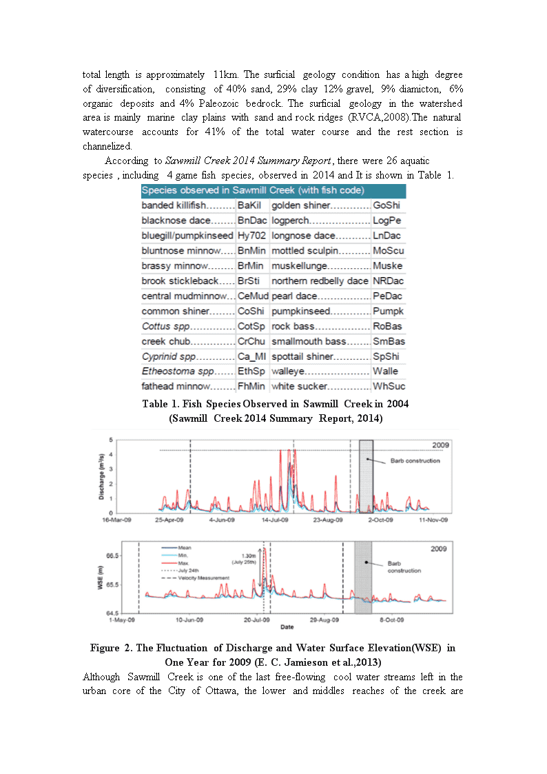
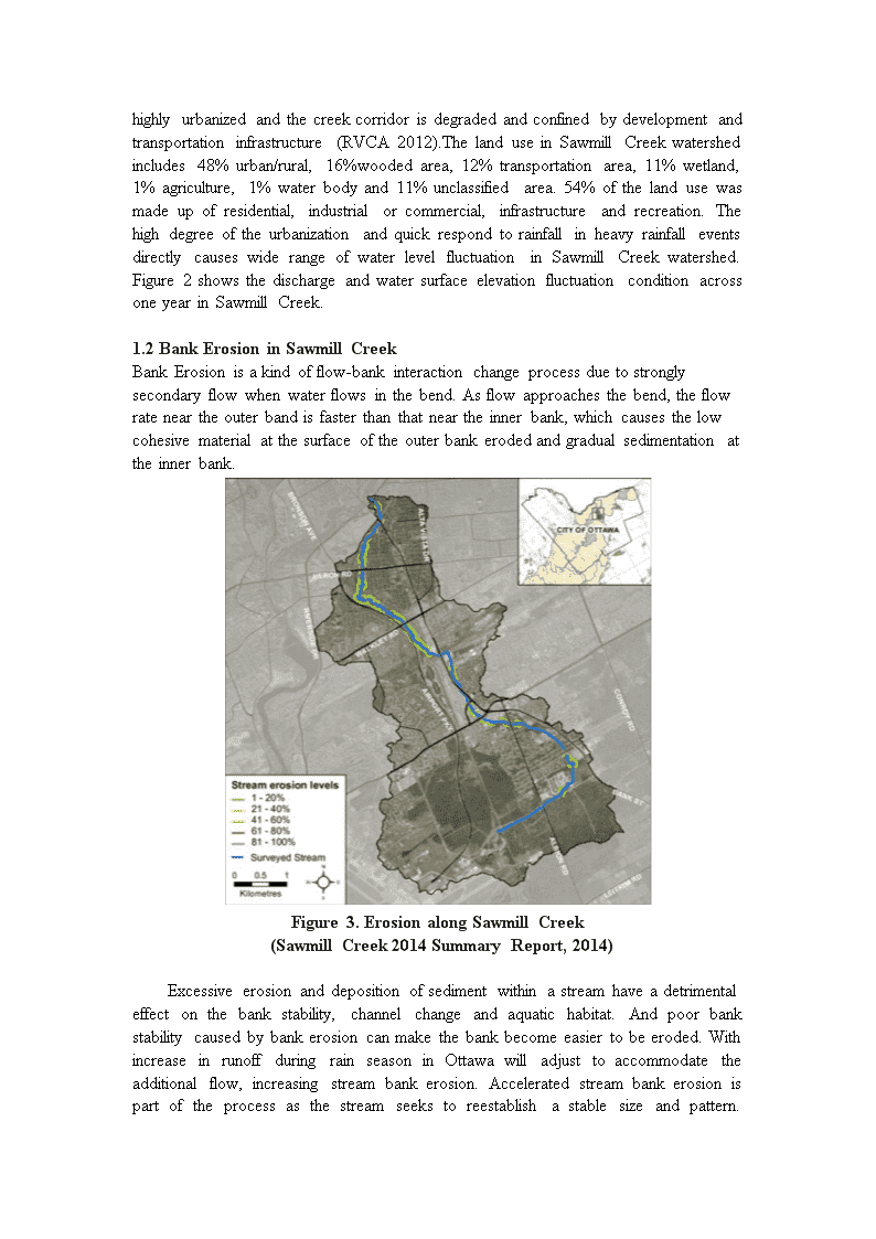
totallengthisapproximately11km.Thesurficialgeologyconditionhasahighdegreeofdiversification,consistingof40%sand,29%clay12%gravel,9%diamicton,6%organicdepositsand4%Paleozoicbedrock.Thesurficialgeologyinthewatershedareaismainlymarineclayplainswithsandandrockridges(RVCA,2008).Thenaturalwatercourseaccountsfor41%ofthetotalwatercourseandtherestsectionischannelized.AccordingtoSawmillCreek2014SummaryReport,therewere26aquaticspecies,including4gamefishspecies,observedin2014andItisshowninTable1.Table1.FishSpeciesObservedinSawmillCreekin2004(SawmillCreek2014SummaryReport,2014)Figure2.TheFluctuationofDischargeandWaterSurfaceElevation(WSE)inOneYearfor2009(E.C.Jamiesonetal.,2013)AlthoughSawmillCreekisoneofthelastfree-flowingcoolwaterstreamsleftintheurbancoreoftheCityofOttawa,thelowerandmiddlesreachesofthecreekare
highlyurbanizedandthecreekcorridorisdegradedandconfinedbydevelopmentandtransportationinfrastructure(RVCA2012).ThelanduseinSawmillCreekwatershedincludes48%urban/rural,16%woodedarea,12%transportationarea,11%wetland,1%agriculture,1%waterbodyand11%unclassifiedarea.54%ofthelandusewasmadeupofresidential,industrialorcommercial,infrastructureandrecreation.ThehighdegreeoftheurbanizationandquickrespondtorainfallinheavyrainfalleventsdirectlycauseswiderangeofwaterlevelfluctuationinSawmillCreekwatershed.Figure2showsthedischargeandwatersurfaceelevationfluctuationconditionacrossoneyearinSawmillCreek.1.2BankErosioninSawmillCreekBankErosionisakindofflow-bankinteractionchangeprocessduetostronglysecondaryflowwhenwaterflowsinthebend.Asflowapproachesthebend,theflowrateneartheouterbandisfasterthanthatneartheinnerbank,whichcausesthelowcohesivematerialatthesurfaceoftheouterbankerodedandgradualsedimentationattheinnerbank.Figure3.ErosionalongSawmillCreek(SawmillCreek2014SummaryReport,2014)Excessiveerosionanddepositionofsedimentwithinastreamhaveadetrimentaleffectonthebankstability,channelchangeandaquatichabitat.Andpoorbankstabilitycausedbybankerosioncanmakethebankbecomeeasiertobeeroded.WithincreaseinrunoffduringrainseasoninOttawawilladjusttoaccommodatetheadditionalflow,increasingstreambankerosion.Acceleratedstreambankerosionispartoftheprocessasthestreamseekstoreestablishastablesizeandpattern.
Damagingorremovingstreamsidevegetationtothepointwhereitnolongerprovidesforbankstabilitycancauseadramaticincreaseinbankerosion(SteamNotes,Volume1Number2).Thelossofbankvegetationisalsoasignificantproblemduetotheinteractionbetweenbankfailureandbankerosion,resultingintreesfallingintothestreamandthepotentialtoimpactinaquatichabitatandmigrationpath.Figure3showshighlevelsofbankerosionwereobservedalongmanysectionsofSawmillCreekdownstreamofWalkleyRoad.Figure4showstheimageofbankerosionhappeninginonebendofSawmillCreek.Figure4.ErosioninOneBendofSawmillCreek(SawmillCreek2014SummaryReport,2014)1.3.StreamBarbsStreambarbatypeofgroynewhichhasbeenusedforcenturiesunderavarietyofpurposesrangingfromrivertrainingtostreambankprotection.Itisakindoflinearrockstructureconnectedwiththebankandstretchingintothechannel.Itistypicallyanchored.Itisoneofthemostreliableandeconomicallyattractiveapproachesforstabilizingerodingbanksinincisedchannels.ThegeneralconfigurationofbarbsisshowninFigure5.Asforthebendareaofthesmallstream,3or4streambarbsaregenerallyinstalledattheouterbankandparallelwitheachotherwithaspacingrangingfrom1mto3m,determinedbyspecificcondition.Barbsaregenerallyconstructedoutoflargerockriprap,between500and600mmindiameter,withadditionalsmallerriprap(d:50~230mm)alongthebanksideslope(50%above/belowbankfull)upstreamofeachbarbtoprovideadditionalprotectioninthearea.(E.C.Jamiesonetal.,2009)Spurswerespacedatroughlytwicetheaveragebaseflowchannelwidth(<7m)withlengthsroughly40percentoftheaveragewidth.Crestswerelevel,2mwide,and1mabovethebed,orabout60cmabovebaseflowwatersurfaceelevation.Stonesizerangedfrom0.2to450kg,with50to85percentofthestonesweighinglessthan36kg(FD.Shieldsetal.,1998).
Figure5.ConceptualDrawingofSpurs(darkerrock)(FD.Shieldsetal.,1998)Thisconfigurationredirectstheattackingcurrentandtheprimarysecondaryflowcellawayfromtheouterbanktowardsthecentreofthechannel(Minoretal.,2007,Jamiesonetal.accepted).Moreover,unlikeotherbankprotectionmeasures(e.g.riprap,concretepavingandgabionwalls),streambarbsrequirelessmaterialandcanpromotevegetatedstreambanks,maintaindeeppoolhabitatthroughthedevelopmentofscourholesatbarbtipsandincreaseaquaticspeciesdiversity(Shieldsetal.,1998;Engelhardetal.,2004).However,StreambarbsdonotaddressbankfailureduetosoilinstabilityandDrawdown(TechnicalNote23:DesignofStreamBarbs,U.S,2005).Therefore,additionalworkshouldbedonebeforethebarbsinstallationsuchasstreamcleanup,vegetativeplantingandsitemonitoring.Theplanistoincorporatevegetativeplantingandotherbioengineeringpracticesduringtheconstructionphasetoaddresstheseadditionalmechanismsofbankfailure(E.C.Jamiesonetal.,2009).Moreover,vegetationprovidesadditionalroughnesstodissipateenergyalongthestreambankandenhanceswildlifehabitatandwaterquality(E.C.Jamiesonetal.,2009).1.4TargetReachInformationThetargetreachofthisstudyisa50-mreachinSawmillCreek,whichgenerallyconsistsoftwosmallbendsandreceivesapproximately90%ofthecontributingwatershedarea.Thereachisexperiencingbankerosionandmasswastingattwoconsecutivebends.Thelineardistanceandareaoferodingbankinthefirst(second)bendwere13.4mand41.7m2(28.0mand46.0m2)(E.C.Jamiesonetal.,2013).Anumberoflargebouldersdominatedthemorphologyofthesecond(downstream)bend,andarifflehadformedclosetotheapexofthebend.(E.C.Jamiesonetal.,2013)targetreachwasselectednotonlybecausetheerodingbanksindicatedthepresenceoferosionprocessesbutalsobecauseofrelativeeaseofsiteaccessandlackofproximitytocriticalinfrastructure.(E.C.Jamiesonetal.,2013)Thesiteimageofthetargetreachandtwobendsarepresentedinfigure2.
Figure6.(A)AerialphotooftheSawmillCreekstudyarea;reddashedlineindicatesrightbankandflowisfromsouthtonorth.(B)Bend1lookingupstream,and(C)outsidebankofbend2lookingdownstream.(E.C.Jamiesonetal.,2009)InSeptember2009,aseriesofsevenstreambarbswereinstalledtoprotectthetwoerodingouterchannelbanksandtoserveasademonstrationprojectfortheuseofthesestructuresinasemi-alluvialchannel(E.C.Jamiesonetal.,2009).Threebarbswereplacedinthefirstupstream)bend,andfourbarbswereplacedintheproceeding(downstream)bend(labeledB4–B7)(Figures1and2)(E.C.Jamiesonetal.,2009).Figure7.StreambarbsatSawmillCreek:(a)bend1and(b)bend2.Barbsarenumberedinthedownstreamdirection.Photostakenon9November2009,
duringlowflowconditions(discharge,Q~0.3m3/s).(E.C.Jamiesonetal.,2013)2.OBJECTIVETable2.BarbInstallationPlanIntheTwoBendsofSawmillCreek(E.C.Jamiesonetal.,2009)Accordingtothebarbdesignplaninpreviousstudy(E.C.Jamiesonetal.,2009),thebarbinstallationanglewasdeterminedduetolaboratoryexperiments(Matsuura,Tetal.,2004andnumericalmodeling(Minor,B.etal,.pp1087-1095).Intheseexperiments,whichconsidered90and135ºchannelbends,optimumbankprotectionwasachievedforaseriesofthreebarbs,eachwithanalignmentangleof30º(E.C.Jamiesonetal.,2009).However,thelengthofstreambarbsaredeterminedduetotheUSDAguidelinesrecommendationvaluewhichsaysbarblengthsshouldnotexceedone-thirdofthecrosssectiontopwidthatbankfullflowbutdoesnotspecifytheoptimumvalueofbarblength.ThebarblengthdesigninthetwobendsofSawmillCreekwasnottakenintoaccountindetail.Itcanbeconcludedthattheremaybeabetterbarbdesignplanwiththeoptimumlengthvalue.TheobjectiveofthispaperistryingtostudytherelevancebetweenthelengthofbarbsandbanderosionreductioneffecttofindtheproperdesignplanforstreambarbsandobtainthebesteffectofbanderosionreductionandaquatichabitatsprotectionusingDelft-3Dhydraulicflowmodel.3.METHODDelft-3Dhydraulicflowmodel(Delft-3D-FLOW)isaunique,fullyintegratedcomputersoftwaresuiteforamulti-disciplinaryapproachand3Dcomputationsforcoastal,riverandestuarineareas.Itcancarryoutsimulationsofflows,sedimenttransports,waves,waterquality,morphologicaldevelopmentsandecology.Ithasbeendesignedforexpertsandnon-expertsalike(Delft3D-FLOW_User_Manual,DeltaresSystem.TheDelft-3Dsuiteiscomposedofseveralmodules,groupedaroundamutualinterface,whilebeingcapabletointeractwithoneanother(Delft3D-FLOW_User_Manual,DeltaresSystem.Itisamulti-dimensional(2Dor3D)
hydrodynamic(andtransport)simulationprogramwhichcalculatesnon-steadyflowandtransportphenomenathatresultfromtidalandmeteorologicalforcingonarectilinearoracurvilinear,boundaryfittedgrid(Delft3D-FLOW_User_Manual,DeltaresSystem).Thegeneralprocessistosimulateseveralflowconditionswithdifferentvalueofbarblengthandanalyzethevelocityandshearstressprofiletoseethedifferences.3.1GridGenerationTheDelft-3D-RGFGRIDinterfaceisusedtogeneratesplinesandgridsbasedonthechannel,whichisthefirststepoftheflowsimulation.ABDCFigure8.GridGeneration
(A:SplineGeneration;B:ChangeSplineintoGrid;C:Orthogonalisation;D:Refinement.)ThechannelichnographyisobtainedfromtheGeographicinformationSystem(GIS)whichcanbeusedtodeterminethelandboundaryinTheDelft-3D-RGFGRIDinterface.Afterdeterminingthelandboundary,severalsplinescanbedrawnalongthechannelandperpendiculartothechannel,roughly.Thesplinesshouldbeassmoothaspossibleandoverlapwiththechannelboundaryasmuchaspossiblewhendrawingtheboundarysplines.Aftersplinesaredetermined,gridcanbegeneratedfromthesplines.Inordertomakethegridcelluniformandsmooth,orthogonalisationshouldbedoneseveraltimesuntilgettingtheoptimumgrid.Thegridwasrefinedtwotimestoimprovetheresolutionintheseregionsforbetterflowandsedimenttransportcalculations.ThefirsttimeofrefinementsetstheMrefinementfactorandNrefinementfactorequalto3and3,andthesecondtimeequalto2and2,respectively.Finally,aoptimumgridwith74pointsinM-directionand14pointsinN-directionisgeneratedsuccessfully.ThisprocessisshowninFigure8.3.2BathymetryGenerationTheDelft-3D-QUICKINinterfaceisusedtogeneratecontinuousbathymetryimagebasedonthedepthdataandthegirdgeneratedpreviously,whichisthesecondstepoftheflowsimulation.BAFigure9.BathymetryImage
(A:Coloredview;B:3Dview)Thedepthdataareobtainedfromfieldmeasurementin36crosssectionsinthetwobendsareaandseveralthalweglinesontheriverbed.Afterthegirdanddepthdatainputisdone,thesizeofgirdcellcanbeaveragedusingGridCellAveragingfunction.Then,thecontinuousbathymetryimagecanbedisplayedthroughtriangularinterpolationandinternaldiffusion.Theinternaldiffusionisusedtofilltheblankdepthdatainthechannel.ThisprocessisshowninFigure93.3VirtualBarbsInstallationTheDelft-3D-FLOW_INPUTinterfaceisusedtosimulateofflowandrecordthedatainobservationpointsandcrosssectionsbasedonthebathymetryimageandthegirdgeneratedpreviously,whichisthethirdstepoftheflowsimulation.ParameterValue/SettingParameterValue/SettingSimulationStartTime13/04/201600:00WaterDensity1000kg/m3SimulationStopTime14/04/201601:00Temperature15℃Duration15minRoughness(Manning)0.05TimeStep0.01minHorizontalEddyViscosity2m2/sTimeIntervalforMapStore120minHorizontalEddyDiffusivity10m2/sHistoryIntervalforMapStore10minVerticalEddyViscosity2m2/sWaterLevel1.0mVerticalEddyDiffusivity10m2/sSalinity30pptOzmidovLengthScale11m2/sUpstreamDischarge2.5m/s3Modelfor3Dturbulancek-EpsilonGravity9.81m/s2ThresholdDepth0.05mTable3.ChannelandFlowParametersSettinginFlowSimulationAfterthegridandbathymetryimageinputisdone,severalchannelandflowparameterscanbedetermined,whichareshownintable3.Theinitialwaterlevelanddischargeweredeterminedusingtheaveragevaluebetweenlowflowandbankfullcondition,whichwere1mand2.5m/s3,respectively.Theopenboundaryconditionatupstreamanddownstreamweresetas‘TotalDischarge’and‘WaterLevel’,respectively.
CBAAFigure10.ThreeBarbLengthPlans(A:Barblengthis0m;B:Barblengthis1.28m;C:Barblengthis2.56m)andObservationpoints(Bluecrossing)andCrossSections(Bluelineacrossthestream)ThelocationofobservationpointsandcrosssectionsweredeterminedasFigure10shows.Theprincipleofobservationsiteselectionistoputobservationsitesbetweeneachbarbsinordertoobservetheflowparameterchangeaccordingtothebarblengthvariation.6virtualbarbswereinstalledattheouterbankwith3virtualbarbsateachbendusingthedrypointfunctioninTheDelft-3D-FLOW_INPUTinterface.AsitisshowninFigure10,threeBarblengthplansweresetas0m,1.28mand2.56m,respectively.Andthemaximumbarblength,2.56m,meetstherequirementofUSDAguidelineswhichrecommendsbarblengthsshouldnotexceedone-thirdofthecrosssectiontopwidth,7.7m,atbankfullflowcondition.BA4.RESULTSC
Figure11.TheHorizontalVelocityResultinThreeBarbLengthplan(A:Barblengthis0m;B:Barblengthis1.28m;C:Barblengthis2.56m)TheDelft-3D-QIUCKPLOTinterfaceisusedtooutputthesimulationresultsbasedontheflowandchannelparametersgeneratedpreviously,whichisthelaststepoftheflowsimulation.ThehorizontalvelocityresultinthreebarblengthplanisshowninFigure11.FromthecomparisonwithFigureAandFigureB,itcanbeseenthatafterbarbinstallation,thehorizontalvelocitydecreasesalongtheouterbank,whichprovesthebarbeffectonreducingthebankerosion.Andthehorizontalvelocityatthecenterofthechannelincreasesslightly.ThecomparisonwithFigureBandFigureAillustratesthatwhenbarblengthincreasestothemaximumvalue,thehorizontalvelocityalongtheouterbankdecreases,whichdirectlyshowsimprovementinreducingthebankerosion.However,italsoshowsthehorizontalvelocityatthecenterofthechannelandoneoftheinnerbankincreasesdramatically.Thismayhaveaeffectontheriverbederosion,resultingintheinstabilityofaquatichabitatandmigration.4.DISCUSSIONThispapergenerallydiscussestherelevancebetweenbarblengthandbankerosionreducingeffectusingDelft-3Dsoftware.Accordingtothesimulationresult,increasingthebarblengthwithintherecommendedrangecanreducethehorizontalvelocityalongtheouterbank,whichcanfurtherreducetheouterbankerosioneffect.However,severallimitationofthispapershouldbeawareof.First,thispaperchoosetheaveragewaterlevelandupstreamdischargevalueofthelowflowandbankfullconditionastheinitialparametersinthestudy.Moredischargeandwaterlevelneedbeinputtostudythestabilityoflongbarbperformanceunderdifferenceflowconditions.Second,Thispaperchoosetheangleofbarbsasaconstantvalue,whichis90°,whilechangingthebarblength.Furtherstudyneedstobedonetostudytherelevancebetweenbarblength,barbangleandbankerosionreducingeffect.Third,thisstudyonlycarriedoutcomputersimulationonthissubject.Labandfieldexperimentsneedtobedonetodeterminethereliabilityoftheexperimentresult.Thispaperprovidesafurtherthinkingintheoptimumbarbdesignplan.Thebarblengthshouldbetakenintoaccountwhendesigningbarbs.Aproperbarblengthcanobtaintheoptimumbankandhabitatprotectioneffect.5.CONCLUSION1.Increasingthebarblengthwithintherecommendedrangecanreducethehorizontalvelocityalongtheouterbank,whichcanfurtherreducetheouterbankerosioneffect.2.Increasingthebarblengthcanalsocausetheincreasingofhorizontalvelocityatthecenterofthechannelandinnerbank,whichmayresultinerosionandinstabilityof
aquatichabitatandmigrationattheselocation.3.Streambarbdesignshouldtakethebarblengthintoaccountandpayattentiontothereducingandincreasingeffectonerosionatdifferentchannellocationinordertofindtheoptimumplan.6.REFERENCESRideauValleyConservationAuthority(RVCA).2008.CityStreamWatchAnnualReport.Manotick,ON:JuliaSuttonJamiesonEC,RennieCD,TownsendRD.2009.DesignofstreambarbsforfieldscaleapplicationatSawmillCreek,Ottawa.WITTransactionsonEcologyandtheEnvironment(ProceedingsofRiverBasinManagementV,Malta,Sep.2009)124:281-292.Shields,F.D.,Knight,S.S.&Cooper,C.M.Additionofspurstostonetoeprotectionforwarmwaterfishhabitatrehabilitation.J.AmericanWaterRes.Ass.,34,pp.1427-1436,1998.ElizabethC.Jamieson,MatthewA.Ruta,ColinD.RennieandRonaldD.Townsend1Monitoringstreambarbperformanceinasemi-alluvialmeanderingchannel:flowfielddynamicsandmorphology.Ecohydrology.6,611–626(2013)Publishedonline6February2013inWileyOnlineLibrary(wileyonlinelibrary.com)DOI:10.1002/eco.1370FD.Shields,Jr.,S.S.Knight,andC.M.Cooper.AdditionofSpurstoStoneToeProtectionForWarmWaterFishHabitatRehabilitation.JournaloftheAmericanWaterResourcesAssociation.Vol.34,No.6.December1998.pp1427-1436.StreamBarbErosion.StreamNotesVolume1,Number2.TheRideauValleyConservation,CityofOttawa,HeronParkCommunityAssociation,OttawaFlyfishersSociety,OttawaStewardshipCouncil,RideauRoundtable,NationalDefenseHQ-FishandGameClub,andtheNationalCapitalCommission.SawmillCreek2014SummaryReport.theCityStreamWatch2014SummaryReport.MinorB,RennieCD,TownsendDR.2007.“Barbs”forriverbendbankprotection:applicationofathree-dimensionalnumericalmodel.CanadianJournalofCivilEngineering34:1087-1095.EngelhardtmC.,Kruger,A.,SukhodolovA.Astudyofphytoplanktonspatialdistributions,flowstructureandcharacteristicsofmixinginariverreachwithgroynes.J.ofPlanktonRes.,26(11),pp.1351-1366,2004.TechnicalNote23:DesignofStreamBarbs,U.S.DepartmentofAgriculture(USDA),NaturalResourcesConservationService,PortlandOregon,2005.Delft3D-FLOW_User_Manual,DeltaresSystem.'
您可能关注的文档
- 计算水力学--第五章(第2讲)课件.ppt
- 长安大学水力学实验课件.ppt
- 水力学综合题.doc
- 水力学-消能复习进程.ppt
- 岩体力学性质水力学性质讲解课件.ppt
- 计算水力学01讲课教案.ppt
- 水力学习题集与问题详解解析汇报.doc
- 水力学习题及问题详解19502.doc
- 四川大学水力学课件讲课教案.ppt
- 水力学(闻德荪)习题答案第三章.doc
- 水力学第五章-第七节课件.ppt
- 垂直流人工湿地水力学特点对污水净化效果的影响(1).pdf
- 广工水力学试题.doc
- 水力学2011年1月试卷.pdf
- 水力学--主要知识点教案资料.ppt
- 深水无隔水管钻井液回收钻井水力学计算.pdf
- 水力学实验报告课件.doc
- 水力学渗流课件.ppt